
The City of Memphis Public Safety Explorer
Implementing ArcGIS Experience Builder for Open Data
Background
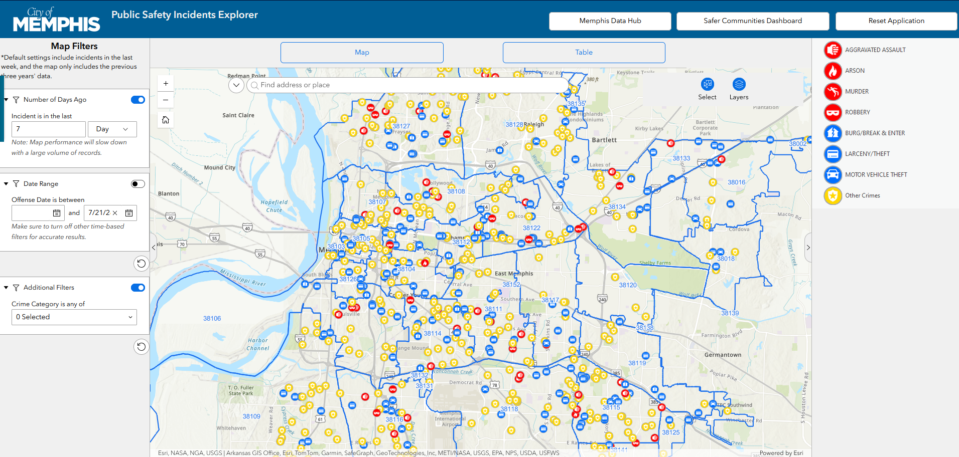
The City of Memphis migrated its open data portal from Socrata to ArcGIS Hub in 2025. One of the biggest priorities of the migration was to recreate the City’s existing crime incidents application. Citizens and data users were familiar with the existing application, so it was important to maintain the functionality and feel of the existing platform while taking advantage of the new functionality of ArcGIS Experience Builder.
My Role
I was responsible for designing and developing the Experience Builder application while working closely with my manager throughout the project.
Rather than starting with an existing template, I built the application from scratch to meet the City's requirements. My responsibilities included:
Designing the application layout and user interface.
Configuring map tools, filters, search, and navigation.
Testing the application and refining it based on user feedback.
Maintaining the application and adding new functionality after deployment.
Another member of our team manages the daily ETL process that prepares the incident data. My role focuses on the Experience Builder application and its ongoing development.
Design Process
Whenever I begin a new project, I spend time looking at how other organizations have approached similar problems.
For this application, I reviewed public safety maps from Detroit, Cleveland, and Nashville. Each application had ideas worth borrowing, whether it was the overall layout, filtering options, or map interaction. Rather than copying any one application, I combined ideas that fit the needs of Memphis and adapted them within Experience Builder.
One decision I made early on was to build the application from scratch rather than modify a template. I have found that starting with a blank project provides more flexibility and makes it easier to understand how the application works as it evolves.
Project Challenges
The largest technical challenge was balancing performance with usability.
Because the incident dataset is very large, displaying every record when the application loads would slow the map considerably. To improve performance, the application initially displays only the previous seven days of incidents while allowing users to explore a much larger date range through filters.
Other challenges included:
Configuring feature selection and popup behavior.
Choosing not to use clustering because it reduced application performance.
Incorporating user feedback from demonstrations and testing sessions.
Designing an application that could easily accommodate future enhancements.
Many of the improvements came from demonstrating the application to users. Questions that seemed simple often revealed opportunities to improve the interface.
Results
The Public Safety Explorer has become one of the City's most frequently used public GIS applications.
The migration preserved the functionality users expected while providing a platform that is easier to maintain and expand. Since its initial release, additional features have been added, including Neighborhood Watch boundaries requested by the Memphis Police Department.
Because the application was built in Experience Builder, new tools and functionality can be incorporated without redesigning the entire application.
Why This Project Matters to Me
During my doctoral research, I needed police incident data that was difficult to obtain. Accessing the information required special requests, and it was not readily available to researchers or the public.
Today, students, researchers, journalists, neighborhood organizations, and citizens can access much of that information through the City's open data resources.
At a recent GIS conference, I attended a presentation where university students demonstrated projects built using data from the Memphis Data Hub. Seeing others use data that is now publicly available reminded me why open data and accessible GIS applications are worth investing in.
Technologies Used
ArcGIS Experience Builder
ArcGIS Online
ArcGIS Hub
ArcGIS Pro
Arcade
Open Data
Spatial Analysis
Data Visualization